

The Aggregate 🔬 December 16th, 2019
The Aggregate 🔬 December 16th, 2019
GIS Edition
Hello! I am Lars E. Schonander, a writer for MediaFile and a blogger on international affairs, tech, and general wonkery. Happy Monday! Here is my weekly newsletter with a weekly analysis with interesting data, along with links related to things I found particularly interesting that week. Any Questions? Send me a message or just respond to this email!
The Weekly Data:
To start, I am sorry for the recent delay in publishing. It has been finals and papers season, so I have needed to devote time to my studies, instead of well, working on this newsletter. For this week, I decided to combine my background in international affairs with some programmatic GIS work.
Starting in 2018, protests have been happening in Nicaragua because of democratic discontent. The president of Nicaragua, Daniel Ortega, a former Sandinista, and current president, enacted a various security laws that proved to be unpopular with the country. Unfortunatly, these first protesters were attacked by Sandinista Youth. As noted by Amnesty International, protesters during this period kept getting attached by state-sponsored violent forces, along with the goverment employing things like tear gas against the protesters.
Back in this period, I actually interned for a non-profit where we one of the projects we did was providing some technical assistance to several non-profits in the country. While I did some a basic analysis of the data provided, now that I have some GIS skills, a more complicated analysis of the protest is possible.
Unfortunatly, I do not quite remember the name of the non-profit, so all sources are labled as question marks unfortunatly.
Mapping it Out
Within R, there is a package called sf which makes it easy to do GIS (Geographic Information Systems) programming in R. This ranges from the creation of points and polygons on a map, to methods such as spatial joins which allow one to combine two separate spatial datasets into one.
To begin, to get the area of the capital of Nicaragua, I used the osmdata package to grab the bounding box in the city. Then, using a spatial join, I grabbed only the points of conflict that were within the Managua bounding box and plotted them out. Additionally, I grabbed some data from Open Street Maps regarding the major streets in the city, to see if the protests were concentrated on the streets. This also required to find the intersection between the streets and the Managua bounding box, to make sure the streets fell within the city limits.

As seen above, a majority of protests fall on the major streets of Managua, with many being clustered in a few city sections. As I could not find a shapefile of the city level divisions, a alternate way of pinpointing which regions had the most protests in the city is required.
Grid Maps
SF is a massive library in general, so there quite a few unusual things the package can do. For example, there is a function called st_make_grid, which makes a grid based on a spatial dataframe. This grid will initially fill up the entire bounding box, and not quite conform to the more natural city borders. However, st_intersection solves this problem quite nicely and will cut the squares to fit the grid. I then joined the grid to the dataframe holding the individual protests, to see given the grid, where are the protests the densest?
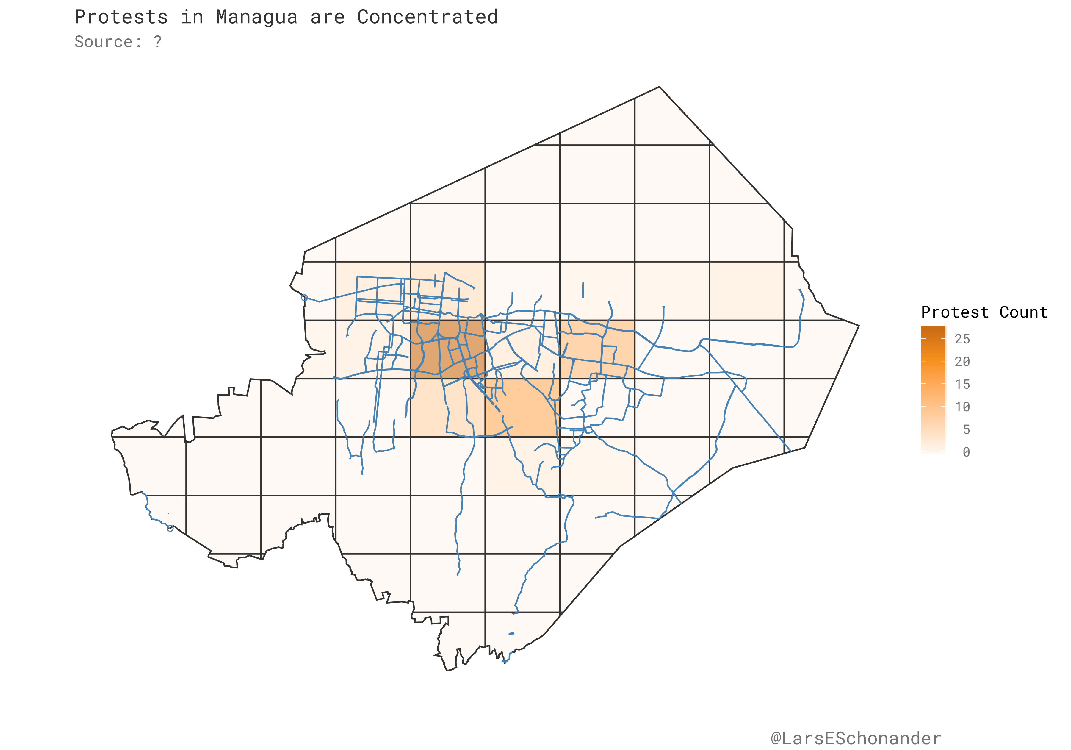
As seen above them, most protests are focused in the city center, with one grid in particular having far more protests then the rest of the city.
GIS for Data Analysis… Which is not Mapping
One useful part of the SF package is that each geometric object has a tibble associated with it, so one can use the tidyverse to do some tidy data analysis based on the data that the sf object has, or will have if one decided to add additional variables to the object.
One example of using this is, given different bounding boxes provided by the OSM package, one can check if a given point falls within a Urban area. In this case, I did this by seeing how many points fell into the top five largest cities in Nicaragua. While the above maps may suggest the protests are mainly an urban phenomenon, in practice, most of the protests occur outside the largest cities!

The trick with the bounding box is required because the dataset lacks a variable for the city where the protest occurs. However, with the bounding box combined with latitude and longitude points, it’s possible to check for each point if it falls into a city’s given bounding box.
Now, some links…
Abraham Othman (AngelList): Startup Growth and Venture Returns
We use AngelList data from thousands of early-stage venture investments to solve for how each successive year of a startup’s existence affects investment returns. This allows us to create a model of how quickly winning venture investments grow and how that rate of growth decays. Our model shows that at the seed stage investors would increase their expected return by broadly indexing into every credible deal, a finding that does not hold at later stages. Our results also suggest that startups staying private longer have created a powerful engine for unbounded wealth creation entirely outside the public markets; we conclude with an argument rooted in social equity for why retail investors should have access to a broad-based index of earlystage venture investments.
Trae Stephens (Anduril): The Ethics of Defense Technology Development: An Investor’s Perspective
A great deal of ink has been spilled on activism inside tech companies regarding the ethics of doing business with the defense community. Much of the current debate within the U.S. technology community tends to frame the issues in binary terms: technologists have a choice — to participate in the “business of war” (as a recent letter by Google employees put it) and become complicit in war’s consequences, or to withdraw from work with the defense community completely. The tech community’s ambivalence regarding the defense sector is understandable. In the post-Cold War geopolitical environment, our collective memory of conflict (to the extent there is one) has too often been characterized by recent experiences of failed nation-building, unmet aspirations for globalization, and the rise of populism.
David Dyzenhaus (Theoretical Inquiries in Law): Kelsen, Heller and Schmitt: Paradigms of Sovereignty Thought
Eyal Benvenisti has sought to provide an optimistic account of international law through reconceptualizing the idea of sovereignty as a kind of trusteeship for humanity. He thus sketches a welcome antidote to trends in recent work in public law including public international law that claim that international law is no more than a cloak for economic and political interests, so that all that matters is which powerful actor gets to decide. In this Article, I approach his position through a discussion of the debate in Weimar about sovereignty between Carl Schmitt, Hans Kelsen and Hermann Heller. I try to show that Heller’s almost unknown legal theory might be helpful to Benvenisti’s position. Heller shared with Schmitt the idea that sovereignty had to have a central role in legal theory and that its role includes a place for a final legal decision. Indeed, much more than Schmitt, Heller regarded all accounts of sovereignty as inherently political. However, in a manner closer to the spirit of Kelsen’s enterprise than to Schmitt’s, he wished to emphasize that the ultimate decider — the sovereign decision unit of the political order of liberal democracy — is entirely legally constituted. Moreover, Heller argued that fundamental principles of legality condition the exercise of a sovereign power in a way that explains the specific legitimacy of legality and which might supply the link between sovereignty and ideas such as trusteeship and humanity.
Zero Cool (Logic Magazine): Oil is the New Data
I remember being nervous when I flew into Atyrau, Kazakhstan. Before boarding the flight, one of the business managers who organized the trip sent me a message with precise instructions on how to navigate the local airport:
Once you land, get into the bus on the right side of the driver. This side opens to the terminal. Pass through immigration, pick up your luggage, and go through Customs. The flight crew will pass out white migration cards. Fill them out, and keep it with your passport. You will need to carry these documents on you at all times once you’ve landed.
Another coworker, who had flown in the night before, warned us not to worry if we found ourselves in jail. Don’t panic if you find yourself in jail. Give me a call and we’ll bail you out. Maybe she was joking.
Jacob Siegel (Gen Magazine): The Cold Dark Truth in the ‘Afghanistan Papers’: America Doesn’t Care About Losing
It doesn’t matter how long it goes on, the United States will never win the war in Afghanistan. This is the reality that senior military leaders and top-level officials have discussed in private for nearly the entire duration of the two-decade-long conflict, as a trove of new documents published earlier this week in the Washington Post revealed.
With a meaningful victory out of the question, the military and political leaders in charge instead pursued a strategy of constantly redefining the war’s goals, lying and dissembling about its progress, and finally, in a bipartisan policy upheld by every president since 2001 and abetted by an absentee Congress, simply refusing to end the war on any terms, a measure that ensured no presidential administration would be held responsible for its failure since a war that never ends cannot be judged definitively lost.
What I’m Reading

During Thanksgiving, I went into the city with a friend to go book shopping. During this time I finally got the chance to pick Alain Bertaud’s new book, Order without Design: How Markets Shape Cities.
Alain Bertaud for refernce, is a very famous urban economist who has worked in cities such as Algiers to working in DC as a urban economist at the World Bank. This book repersents a refinement of his work as a economist working in places with and without strong market based systems for allocating land, such as when he worked in Beijing. The book is essentially a combination of a book on market based urban economics, with Alain writing on topics such as commute times or how regulations change where buildings are built in cities.
What I’m Working On
As seen with the subject of this latest newsletter, I have been getting into GIS work in R. It’s quite fun! It ranges from working with vector data and combining it with other datasets such as shapefiles, to working with raster files and learning the basics of map algebra.
I also just finished my 2nd to last semester of college, so I have one semester left until I graduate from university with a degree in International Affairs and Economics. It’s shocking how fast college is, considering there is only five months left essentially.
Thanks!
Thanks for taking the time to read this, I will be back next Monday. In the meantime, you can follow me on Twitter or reach out via email.